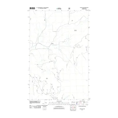
2011 Map of Havillah
USGS Topo · Published 2011About this map
Havillah serves as the central hub of this Okanogan County landscape, where the confluence of several rural routes including Havillah Rd and W Lost Lake Rd marks a historic mountain settlement. The terrain is defined by significant elevations, notably Bimetalic Mountain in the northeast and Mount Phoebe to the southwest, which dictate the drainage patterns of Antoine Creek and Mill Creek. To the north, Eden Valley provides a distinct geographic basin near Knob Hill, while the southern reaches of the map are defined by the headwaters of North Fork Siwash Creek. This 2011 survey reveals a landscape of dispersed agricultural and mountain living, with named springs like Lightning Spring and Division Spring indicating the vital importance of water sources in this high-country environment. The road network, featuring names like Swanson Mill Rd and Dry Gulch Rd, suggests a history of timber and ranching that has long sustained the area.
Find a feature on this map
22 named features on this map. Tap any name to fly to it.
Don’t see what you’re looking for? This feature index may not catch every label — zoom into the map to look around manually.
Map Details
Editions of this 2011 Havillah Map
This is the sole edition of this map. No revisions or reprints were ever made.
Other maps of this area

1902 · Osoyoos
USGS Topo · 1:125,000

1904 · Osoyoos
USGS Topo · 1:125,000

1954 · Okanogan
USGS Topo · 1:250,000

1957 · Mt. Bonaparte
USGS Topo · 1:62,500

1957 · Tonasket
USGS Topo · 1:62,500

1957 · Oroville
USGS Topo · 1:62,500

1957 · Aeneas Valley
USGS Topo · 1:62,500

1958 · Okanogan
USGS Topo · 1:250,000
1981 · Barker Mtn
USGS Topo · 1:24,000
1981 · Burge Mtn
USGS Topo · 1:24,000