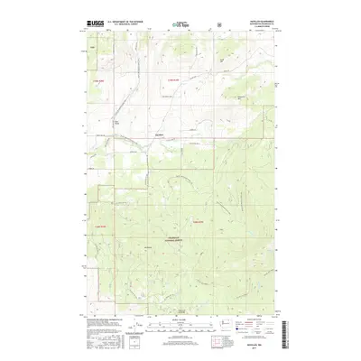
2017 Map of Havillah
USGS Topo · Published 2017About this map
Havillah and the surrounding high-country settlements of Eden Valley define the landscape of this northern Okanogan County study. Much of the southern and eastern territory is dominated by the Okanogan National Forest, where the terrain climbs toward prominent landmarks like Mt Phoebe and Bimetallic Mtn. The map reveals a complex network of forest development roads and trails, including the Pacific NW National Scenic Trail, which threads through the valleys and over the ridges. This high-altitude drainage system is anchored by Antoine Creek and the headwaters of the Middle Fork Siwash Creek. The placement of a lone Cabin near Fourth of July Ridge and various springs like Owl Spring and Division Spring suggest a history of seasonal ranching or mountain recreation in this isolated interior region.
Find a feature on this map
39 named features on this map. Tap any name to fly to it.
Don’t see what you’re looking for? This feature index may not catch every label — zoom into the map to look around manually.
Map Details
Editions of this 2017 Havillah Map
This is the sole edition of this map. No revisions or reprints were ever made.
Other maps of this area

1902 · Osoyoos
USGS Topo · 1:125,000

1904 · Osoyoos
USGS Topo · 1:125,000

1954 · Okanogan
USGS Topo · 1:250,000

1957 · Mt. Bonaparte
USGS Topo · 1:62,500

1957 · Tonasket
USGS Topo · 1:62,500

1957 · Oroville
USGS Topo · 1:62,500

1957 · Aeneas Valley
USGS Topo · 1:62,500

1958 · Okanogan
USGS Topo · 1:250,000
1981 · Barker Mtn
USGS Topo · 1:24,000
1981 · Burge Mtn
USGS Topo · 1:24,000