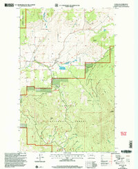
2001 Map of Havillah
USGS Topo · Published 2004About this map
Havillah serves as a central point of settlement in this high-country landscape, positioned near the headwaters of Mill Creek and Antoine Creek. The map documents a transition from the agricultural clearings of Eden Valley to the heavily forested slopes of the Okanogan National Forest, where peaks like Mount Bonaparte and Bimetallic Mountain dominate the horizon. Local history is preserved through the location of the community Cem, while several remote outposts including Napoli Cabin and Roggow Cabin are noted along the drainage of North Fork Siwash Creek. This 2001 revision highlights the area's recreational development, specifically at the Highlands Snowpark, alongside long-established resource extraction sites like the various Gravel Pits found near the valley floors.
Find a feature on this map
25 named features on this map. Tap any name to fly to it.
Don’t see what you’re looking for? This feature index may not catch every label — zoom into the map to look around manually.
Map Details
Editions of this 2001 Havillah Map
This is the sole edition of this map. No revisions or reprints were ever made.
Other maps of this area

1902 · Osoyoos
USGS Topo · 1:125,000

1904 · Osoyoos
USGS Topo · 1:125,000

1954 · Okanogan
USGS Topo · 1:250,000

1957 · Mt. Bonaparte
USGS Topo · 1:62,500

1957 · Tonasket
USGS Topo · 1:62,500

1957 · Oroville
USGS Topo · 1:62,500

1957 · Aeneas Valley
USGS Topo · 1:62,500

1958 · Okanogan
USGS Topo · 1:250,000
1981 · Barker Mtn
USGS Topo · 1:24,000
1981 · Burge Mtn
USGS Topo · 1:24,000