
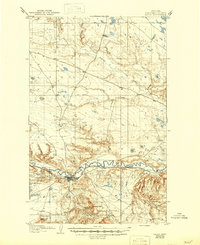
1904 Map of Havre
USGS Topo · Published 1904About this map
Havre serves as the focal point of this northern Montana landscape, situated along the southern bank of the winding Milk River just after the turn of the century. The town's early growth is deeply connected to the Great Northern R. R., which follows the river valley and passes through the smaller settlement of Toledo. To the southwest, the Fort Assinniboine Mil. Res. marks a significant military presence near the foothills of Squaw Butte.
Find a feature on this map
27 named features on this map. Tap any name to fly to it.
Don’t see what you’re looking for? This feature index may not catch every label — zoom into the map to look around manually.
Map Details
Editions of this 1904 Havre Map
2 editions found
Other maps of this area

1904 · Yantic
USGS Topo · 1:62,500

1904 · Assinniboine
USGS Topo · 1:62,500

1912 · Zurich
USGS Topo · 1:125,000

1912 · Thibedeau Lake
USGS Topo · 1:125,000

1953 · Havre
USGS Topo · 1:250,000

1956 · Lloyd
USGS Topo · 1:62,500

1957 · Havre
USGS Topo · 1:250,000

1958 · Havre
USGS Topo · 1:250,000

1959 · Laredo
USGS Topo · 1:62,500

1959 · Shambo
USGS Topo · 1:62,500
Featured Places
- Havre, MT
- Pats Trailer Park, MT
- Bitterroot Trailer Court, MT
- Shennum Trailer Court, MT
- Thiels West Trailer Court, MT