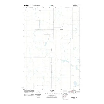
2011 Map of Hawks Nest
USGS Topo · Published 2011About this map
Hawks Nest rises as a prominent topographical landmark above the surrounding prairie of Stutsman County, overlooking a network of seasonal wetlands and glacial potholes. The meandering course of Little Pipestem Creek threads through the western half of the landscape, defining the drainage pattern for the local watershed. This 2011 survey by the U.S. Geological Survey illustrates the rigid section-line road system that organizes the North Dakota interior. Thoroughfares such as 55th Ave SE and 7th St SE form a precise grid across the undulating terrain, reflecting the long-standing land divisions of the Great Plains. The map is primarily characterized by its hydrography, showing numerous small, unnamed water bodies and prairie potholes that are critical to the region's ecology and reflect the post-glacial geology of the Missouri Coteau transition.
Find a feature on this map
16 named features on this map. Tap any name to fly to it.
Don’t see what you’re looking for? This feature index may not catch every label — zoom into the map to look around manually.
Map Details
Editions of this 2011 Hawks Nest Map
This is the sole edition of this map. No revisions or reprints were ever made.
Other maps of this area

1948 · Carrington
USGS Topo · 1:62,500

1950 · Carrington SW
USGS Topo · 1:24,000

1950 · Carrington West
USGS Topo · 1:24,000

1951 · Dover
USGS Topo · 1:24,000

1951 · Sykeston
USGS Topo · 1:24,000

1952 · New Rockford
USGS Topo · 1:250,000

1956 · New Rockford
USGS Topo · 1:250,000

1958 · Goldwin
USGS Topo · 1:24,000

1971 · New Rockford
USGS Topo · 1:250,000

1972 · Woodworth
USGS Topo · 1:24,000