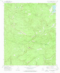
1976 Map of Hawley Lake West
USGS Topo · Published 1977About this map
Hawley Lake serves as a focal point within the high-elevation terrain of the Fort Apache Indian Reservation in the mid-1970s. The landscape is characterized by a dense network of water management features and cattle-working infrastructure, including Lone Pine Tank No 1, Woolsey Lake, and the Horse Mesa Trap. A complex system of drainage is evident through Diamond Creek and Bear Flat Creek, which carve through the volcanic and sedimentary formations marked by McKays Peak and Pistol Butte. The map reveals a transition toward recreational land use in the White Mountain region, evidenced by the development of the Walton Picnic Area, several campgrounds near the lakeshore, and a Borrow Pit indicating local road maintenance. The county line between Navajo and Apache Counties bisects the western half, while numerous jeep trails provide access to the timbered ridges and interior valleys.
Find a feature on this map
37 named features on this map. Tap any name to fly to it.
Don’t see what you’re looking for? This feature index may not catch every label — zoom into the map to look around manually.
Map Details
Editions of this 1976 Hawley Lake West Map
This is the sole edition of this map. No revisions or reprints were ever made.
Other maps of this area

1886 · St Johns
USGS Topo · 1:250,000

1892 · St Johns
USGS Topo · 1:250,000

1954 · Clifton
USGS Topo · 1:250,000

1954 · Saint Johns
USGS Topo · 1:250,000

1957 · Clifton
USGS Topo · 1:250,000

1957 · Saint Johns
USGS Topo · 1:250,000

1958 · Clifton
USGS Topo · 1:250,000

1958 · Saint Johns
USGS Topo · 1:250,000

1961 · McNary
USGS Topo · 1:62,500

1962 · Clifton
USGS Topo · 1:250,000