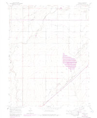
1966 Map of Hawley
USGS Topo · Published 1985About this map
Hawley and Roberta anchor this portion of Otero County, where the landscape is defined by an intricate network of irrigation infrastructure designed to tame the high plains. The Rocky Ford Highline Canal, Otero Canal, and Catlin Canal wind across the terrain, illustrating the critical role of water management in Colorado's agricultural development. This survey, grounded in 1964 and 1966 fieldwork with 1980s updates, documents the intersection of modern logistics and western history. The Atchison Topeka and Santa Fe railroad corridor runs parallel to the legendary Santa Fe Trail, tracing a historic path of commerce and migration. Local educational roots are visible at the Grand Valley Sch, while the presence of the Crooked Arroyo Reservoir No 2 and various gravel pits indicates a landscape actively utilized for both resource extraction and water storage along Timpas Creek.
Find a feature on this map
16 named features on this map. Tap any name to fly to it.
Don’t see what you’re looking for? This feature index may not catch every label — zoom into the map to look around manually.
Map Details
Editions of this 1966 Hawley Map
4 editions found

Other maps of this area

1891 · Catlin
USGS Topo · 1:125,000

1891 · Timpas
USGS Topo · 1:125,000

1893 · Catlin
USGS Topo · 1:125,000

1894 · Timpas
USGS Topo · 1:125,000

1953 · Cheraw
USGS Topo · 1:24,000

1954 · Manzanola
USGS Topo · 1:24,000

1954 · Lamar
USGS Topo · 1:250,000

1955 · Rocky Ford
USGS Topo · 1:24,000

1955 · La Junta
USGS Topo · 1:250,000

1958 · La Junta
USGS Topo · 1:250,000