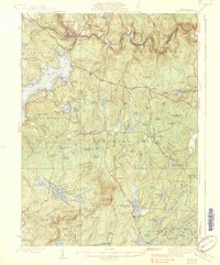
1938 Map of Hawley
USGS Topo · Published 1938About this map
Lake Wallenpaupack dominates the northwestern landscape of this Pike and Wayne County region, reflecting the significant transformation of the terrain following the reservoir's creation in the mid-1920s. Along the winding Lackawaxen River, the Erie Railroad tracks and the Roosevelt Highway trace the valley floor, connecting riverside settlements like Glen Eyre and Rowland. The upland interior of Blooming Grove and Greene townships remains a dense network of glacial wetlands and ridges, characterized by numerous named swamps such as Decker Swamp and Balsam Swamp. Elevated landmarks like the High Knob Fire Tower and Bear Trap Mtn punctuate the Pocono Mountains geography. This 1930s survey captures a rural landscape where social life centered on institutions like Paupack Ch and local schoolhouses, including Blooming Grove Sch and Greeley Sch, before the full modernization of the regional road network.
Find a feature on this map
82 named features on this map. Tap any name to fly to it.
Don’t see what you’re looking for? This feature index may not catch every label — zoom into the map to look around manually.
Map Details
Editions of this 1938 Hawley Map
3 editions found

Other maps of this area

1891 · Wallpack
USGS Topo · 1:62,500

1892 · Honesdale
USGS Topo · 1:62,500

1893 · Wallpack
USGS Topo · 1:62,500

1913 · Milford
USGS Topo · 1:62,500

1915 · Milford
USGS Topo · 1:62,500

1919 · Pocono
USGS Topo · 1:62,500

1920 · Damascus
USGS Topo · 1:62,500

1921 · Pocono
USGS Topo · 1:62,500

1922 · White Lake
USGS Topo · 1:62,500

1923 · Damascus
USGS Topo · 1:62,500