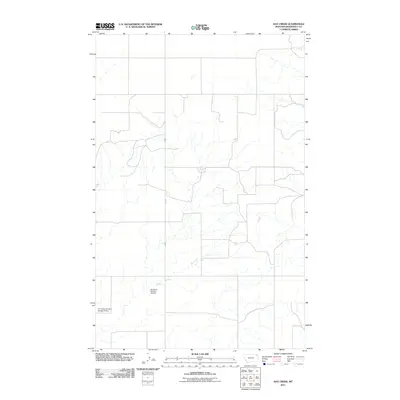
2011 Map of Hay Creek
USGS Topo · Published 2011About this map
Hay Creek winds through this section of Roosevelt County, Montana, defining the local drainage and topography in the early 21st century. This arid landscape is punctuated by water management features such as Structure Number 119 Dam and the CCC Indian Division Number 5 Dam. The latter carries a specific connection to the Civilian Conservation Corps (CCC) Indian Division, reflecting a legacy of New Deal era infrastructure and land improvement on tribal lands. Transportation across this portion of the Brockton District is facilitated primarily by the north-south route of Fas 251, which provides a corridor through the grid-like system of local roads and sections.
Find a feature on this map
4 named features on this map. Tap any name to fly to it.
Don’t see what you’re looking for? This feature index may not catch every label — zoom into the map to look around manually.
Map Details
Editions of this 2011 Hay Creek Map
This is the sole edition of this map. No revisions or reprints were ever made.
Other maps of this area

1909 · Smoke Creek
USGS Topo · 1:62,500

1912 · Hay Creek
USGS Topo · 1:62,500

1912 · Smoke Creek
USGS Topo · 1:62,500

1954 · Wolf Point
USGS Topo · 1:250,000

1958 · Wolf Point
USGS Topo · 1:250,000

1973 · Pleasant Prairie
USGS Topo · 1:24,000

1973 · Pleasant Prairie SW
USGS Topo · 1:24,000

1982 · Culbertson
USGS Topo · 1:100,000
1983 · Hay Creek NW
USGS Topo · 1:24,000
1983 · Smoke Creek SW
USGS Topo · 1:24,000