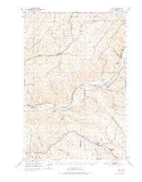
1950 Map of Hay
USGS Topo · Published 1975About this map
Snake River frontage and the deep canyon systems of southeast Washington define this 1950s landscape, captured just before major hydroelectric developments altered the river’s character. The Union Pacific railroad tracks follow the course of Alkali Flat Creek through the settlement of Hay, connecting small agricultural outposts like Jerita and Shreck to the regional grain trade. The map shows a transition from the high plateau wheat lands down to the river bottoms at Central Ferry, where the Central Ferry School and Peyton School once served a dispersed ranching community. Further south, the terrain breaks into steep drainage systems including Pataha Valley and New York Gulch. Social landmarks of the era are clearly marked, such as Selbu Church in the north and the Pataha Valley Grange near the junction of Pataha Creek and Chard Gulch, reflecting the region's deep-rooted agrarian heritage.
Find a feature on this map
45 named features on this map. Tap any name to fly to it.
Don’t see what you’re looking for? This feature index may not catch every label — zoom into the map to look around manually.
Map Details
Editions of this 1950 Hay Map
2 editions found
Other maps of this area

1919 · Walla Walla
USGS Topo · 1:125,000

1921 · Walla Walla
USGS Topo · 1:125,000

1937 · Pomeroy
USGS Topo · 1:96,000

1942 · Pomeroy
USGS Topo · 1:125,000

1948 · Starbuck
USGS Topo · 1:62,500

1950 · La Crosse
USGS Topo · 1:62,500

1950 · Starbuck
USGS Topo · 1:62,500

1950 · Penawawa
USGS Topo · 1:62,500

1950 · Endicott
USGS Topo · 1:62,500

1950 · Hay
USGS Topo · 1:62,500