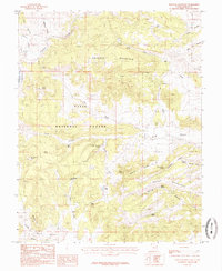
1985 Map of Haycock Mountain
USGS Topo · Published 1985About this map
Dixie National Forest defines the character of this high-elevation landscape, where numerous springs and seeps provided critical water sources for the cattlemen and homesteaders of the mid-1980s. The map highlights the rugged transition from Haycock Mountain in the north to Hatch Mountain in the southeast, with drainage networks feeding into Panguitch Lake and Panguitch Creek. A distinct pattern of resource management is evident through features like John Cameron Troughs, Serviceberry Spring, and Miller Seep, which point to the long history of livestock grazing in these highlands. Transportation through the area is marked by The Pass and the winding course of Mexican Hollow, providing access to the broad expanses of Black Rock Valley in the south. This survey captures a moment when traditional land use, from small-scale mining at several noted pits to seasonal water management, persisted within the federal forest boundaries.
Find a feature on this map
42 named features on this map. Tap any name to fly to it.
Don’t see what you’re looking for? This feature index may not catch every label — zoom into the map to look around manually.
Map Details
Editions of this 1985 Haycock Mountain Map
This is the sole edition of this map. No revisions or reprints were ever made.
Other maps of this area

1886 · Kanab
USGS Topo · 1:250,000

1953 · Cedar City
USGS Topo · 1:250,000

1958 · Cedar City
USGS Topo · 1:250,000

1958 · Panguitch Lake
USGS Topo · 1:62,500

1962 · Cedar City
USGS Topo · 1:250,000

1966 · Hatch
USGS Topo · 1:24,000

1966 · George Mtn
USGS Topo · 1:24,000

1971 · Fivemile Ridge
USGS Topo · 1:24,000
1971 · Panguitch
USGS Topo · 1:24,000
1971 · Red Creek Reservoir
USGS Topo · 1:24,000