
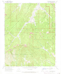
1966 Map of George Mtn
USGS Topo · Published 1968About this map
The Sevier River valley carves through the high plateau of southern Utah in the mid-1960s, marking a significant boundary between Garfield and Kane Counties. This landscape is defined by the transition from the irrigated valley floors near the Panguitch Fish Hatchery to the dramatic elevations of the Dixie National Forest. High-altitude features like Mammoth Ridge and George Mtn overlook a network of seasonal drainages, including Asay Creek and Mammoth Creek. The map documents a rugged interior accessible primarily by Jeep Trail and Pack Trail, highlighting the remote character of Sunset Cliffs and Don Spring Mtn. This survey captures the area before modern development, focusing on the natural water sources and geological formations that dictated the path of early travelers and livestock through Sand Pass.
Find a feature on this map
22 named features on this map. Tap any name to fly to it.
Don’t see what you’re looking for? This feature index may not catch every label — zoom into the map to look around manually.
Map Details
Editions of this 1966 George Mtn Map
This is the sole edition of this map. No revisions or reprints were ever made.
Other maps of this area

1886 · Kanab
USGS Topo · 1:250,000

1953 · Cedar City
USGS Topo · 1:250,000

1958 · Cedar City
USGS Topo · 1:250,000

1958 · Orderville
USGS Topo · 1:62,500

1958 · Panguitch Lake
USGS Topo · 1:62,500

1962 · Cedar City
USGS Topo · 1:250,000

1966 · Wilson Peak
USGS Topo · 1:24,000

1966 · Alton
USGS Topo · 1:24,000

1966 · Hatch
USGS Topo · 1:24,000
1966 · Podunk Creek
USGS Topo · 1:24,000