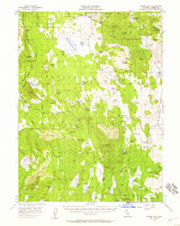
1956 Map of Hayden Hill
USGS Topo · Published 1959About this map
Hayden Hill stands as the central landmark of this Northern California landscape, where the high desert meets the volcanic terrain of the Modoc National Forest. In the mid-1950s, this area across the Lassen and Modoc line was characterized by a network of seasonal camps and water management, essential for ranching and resource extraction in the high-elevation flats. The map reveals numerous isolated outposts like Pat Morris Camp and Totten Camp, alongside industrial markers such as several labeled prospects and a small Cem near the primary peak.
Find a feature on this map
106 named features on this map. Tap any name to fly to it.
Don’t see what you’re looking for? This feature index may not catch every label — zoom into the map to look around manually.
Map Details
Editions of this 1956 Hayden Hill Map
3 editions found

Other maps of this area

1886 · Alturas
USGS Topo · 1:250,000

1886 · Honey Lake
USGS Topo · 1:250,000

1886 · Lassen Peak
USGS Topo · 1:250,000

1886 · Modoc Lava Bed
USGS Topo · 1:250,000

1891 · Honey Lake
USGS Topo · 1:250,000

1892 · Modoc Lava-Bed
USGS Topo · 1:250,000

1892 · Lassen Peak
USGS Topo · 1:250,000

1892 · Alturas
USGS Topo · 1:250,000

1893 · Honey Lake
USGS Topo · 1:250,000

1894 · Lassen Peak
USGS Topo · 1:250,000