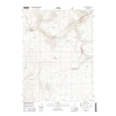
2014 Map of Hayden Peak
USGS Topo · Published 2014About this map
Hayden Pass serves as a critical high-altitude corridor where the Summit and Duchesne County line follows the drainage divide of the Uinta Mountains. This 2014 survey documents a landscape of glacial cirques and alpine basins, including the notable Naturalist Basin, Murdock Basin, and Four Lakes Basin. The drainage patterns are meticulously recorded, showing the headwaters of the Hayden Fork flowing north and the Duchesne River and its tributaries, such as the Stillwater Fork, carving deep canyons to the south. State Hwy 150 winds through the western portion, providing access to remote recreational sites like the Highline Trail Head Campground and Butterfly Campground. The map traces the Highline Trail across the high country, connecting alpine summits like Mt Agassiz and Hayden Peak.
Find a feature on this map
88 named features on this map. Tap any name to fly to it.
Don’t see what you’re looking for? This feature index may not catch every label — zoom into the map to look around manually.
Map Details
Editions of this 2014 Hayden Peak Map
This is the sole edition of this map. No revisions or reprints were ever made.
Other maps of this area

1885 · Uinta
USGS Topo · 1:250,000

1901 · Hayden Peak
USGS Topo · 1:125,000

1903 · Hayden Peak
USGS Topo · 1:125,000

1954 · Salt Lake City
USGS Topo · 1:250,000

1958 · Salt Lake City
USGS Topo · 1:250,000

1960 · Salt Lake City
USGS Topo · 1:250,000

1967 · Explorer Peak
USGS Topo · 1:24,000
1967 · Tworoose Pass
USGS Topo · 1:24,000
1967 · Red Knob
USGS Topo · 1:24,000
1972 · Iron Mine Mountain
USGS Topo · 1:24,000