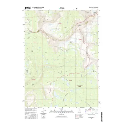
2017 Map of Hayden Peak
USGS Topo · Published 2017About this map
Hayden Peak and Mt Agassiz anchor this high-elevation landscape along the border of Wasatch National Forest and Ashley National Forest. The geography is defined by a dense network of glacial basins and alpine lakes, including the concentrated clusters within Naturalist Basin and Four Lakes Basin. Long-established backcountry routes like the Uinta Highline Trail and the Fish Creek Trail - Granddaddy provide the primary means of traversal through the drainage divide where the E Fork Duchesne River originates. The map captures the specialized recreational infrastructure of the High Uintas in the early 21st century, from the River Run ATV Trail in the west to remote water bodies like Governor Dern Lake and Amethyst Lake in the east. Brinton Meadow and Marsell Canyon sit at lower elevations, showing the transition from the high peaks toward the Uinta Valley.
Find a feature on this map
99 named features on this map. Tap any name to fly to it.
Don’t see what you’re looking for? This feature index may not catch every label — zoom into the map to look around manually.
Map Details
Editions of this 2017 Hayden Peak Map
This is the sole edition of this map. No revisions or reprints were ever made.
Other maps of this area

1885 · Uinta
USGS Topo · 1:250,000

1901 · Hayden Peak
USGS Topo · 1:125,000

1903 · Hayden Peak
USGS Topo · 1:125,000

1954 · Salt Lake City
USGS Topo · 1:250,000

1958 · Salt Lake City
USGS Topo · 1:250,000

1960 · Salt Lake City
USGS Topo · 1:250,000

1967 · Explorer Peak
USGS Topo · 1:24,000
1967 · Tworoose Pass
USGS Topo · 1:24,000
1967 · Red Knob
USGS Topo · 1:24,000
1972 · Iron Mine Mountain
USGS Topo · 1:24,000