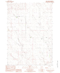
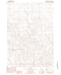
1983 Map of Hayes North
USGS Topo · Published 1983About this map
Frozen Man Creek and Wagonhound Creek carve through this central South Dakota landscape, defining the drainage patterns for the sprawling cattle operations that dominate the region. This 1983 provisional survey highlights the specific family lineages tied to the land, including the B Stoeser Ranch, A Stoeser Ranch, and properties belonging to the Burgeson family such as the A A Burgeson Ranch. The presence of a Historical Marker in the northern portion of the quadrangle suggest points of local significance on the open range. Further south, the Hayes Airport and the Riggle Ranch serve as primary landmarks in this sparsely populated section of Stanley County, where unimproved roads and trails form the backbone of the local transport network.
Find a feature on this map
11 named features on this map. Tap any name to fly to it.
Don’t see what you’re looking for? This feature index may not catch every label — zoom into the map to look around manually.
Map Details
Editions of this 1983 Hayes North Map
This is the sole edition of this map. No revisions or reprints were ever made.
Other maps of this area

1954 · Pierre
USGS Topo · 1:250,000

1958 · Pierre
USGS Topo · 1:250,000
1980 · Princes Ranch
USGS Topo · 1:25,000
1982 · Sansarc
USGS Topo · 1:24,000
1982 · Hayes South
USGS Topo · 1:24,000

1982 · Whiteman Ranch
USGS Topo · 1:24,000
1982 · Hohrman Ranch
USGS Topo · 1:24,000

1982 · May Ranch
USGS Topo · 1:24,000

1983 · Bentley Ranch
USGS Topo · 1:24,000
1983 · Standing Butte SW
USGS Topo · 1:24,000