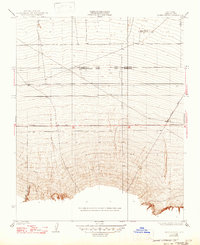
1933 Map of Hayes Ranch
USGS Topo · Published 1947About this map
Hayes Ranch serves as a primary landmark in this southern Kern County landscape, where the flatlands of the San Joaquin Valley begin their ascent into the foothills. Surveyed in the early 1930s, the map reveals a critical geographic juncture where two major surveying systems meet: the Mt Diablo Base and Meridian and the San Bernardino Base and Meridian. This convergence is a rare cartographic detail, marking the boundary between distinct regional land divisions.
Find a feature on this map
7 named features on this map. Tap any name to fly to it.
Don’t see what you’re looking for? This feature index may not catch every label — zoom into the map to look around manually.
Map Details
Editions of this 1933 Hayes Ranch Map
3 editions found
Other maps of this area

1903 · Mt. Pinos
USGS Topo · 1:125,000

1910 · Buena Vista Lake
USGS Topo · 1:125,000

1912 · Buena Vista Lake
USGS Topo · 1:125,000

1929 · Mouth of Kern
USGS Topo · 1:31,680

1930 · Millux
USGS Topo · 1:31,680

1930 · Conner
USGS Topo · 1:31,680

1931 · Pentland Junction
USGS Topo · 1:31,680

1931 · Hayes Ranch
USGS Topo · 1:31,680

1932 · Mouth of Kern
USGS Topo · 1:31,680

1933 · Hayes Ranch
USGS Topo · 1:31,680