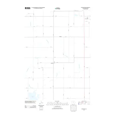
2013 Map of Hayfield
USGS Topo · Published 2013About this map
Hayfield and Hawley anchor this agricultural landscape in Hancock County, where a strictly organized grid of rural roads defines the movement across the prairie. The survey reveals how the local hydrology has been managed to support modern farming, most notably through the channelization of the W Br Iowa River and the E Br Iowa River. The southern portion of the quadrangle is dominated by the natural basin of Eagle Lake, which stands in contrast to the engineered geometry of Drainage Ditch Number 129. To the northeast, the Forest City Municipal Airport marks a point of modern infrastructure near the settlement of Madison. This 2013 record is essential for understanding the contemporary intersection of Iowa's natural waterways and the relentless expansion of the township-and-range road system.
Find a feature on this map
31 named features on this map. Tap any name to fly to it.
Don’t see what you’re looking for? This feature index may not catch every label — zoom into the map to look around manually.
Map Details
Editions of this 2013 Hayfield Map
This is the sole edition of this map. No revisions or reprints were ever made.
Other maps of this area

1954 · Mason City
USGS Topo · 1:250,000

1957 · Mason City
USGS Topo · 1:250,000

1958 · Mason City
USGS Topo · 1:250,000

1972 · Forest City
USGS Topo · 1:24,000

1972 · Hayfield
USGS Topo · 1:24,000

1972 · Crystal Lake
USGS Topo · 1:24,000

1972 · Pilot Knob
USGS Topo · 1:24,000
1972 · Thompson
USGS Topo · 1:24,000
1972 · Duncan
USGS Topo · 1:24,000
1972 · Miller
USGS Topo · 1:24,000