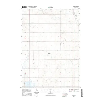
2015 Map of Hayfield
USGS Topo · Published 2015About this map
The town of Forest City anchors the northeastern corner of this Iowa landscape, where the prairie gives way to the managed waterways of Hancock and Winnebago counties. In the southern portion of the quadrangle, Eagle Lake and its surrounding wetlands provide a natural contrast to the grid-patterned agricultural fields that dominate the terrain. This 2015 survey illustrates a highly engineered hydrological network, including Drainage Ditch Number 129 and the split branches of the Iowa River. The West Branch, labeled as both West Br Iowa River and W Br Iowa River, meanders toward the small settlement of Hayfield in the center of the map. Local history and genealogy interests are served by the location of Madison Cem and the extensive network of numbered county roads, such as Co RD b16 and Co RD b30, which trace the original section lines of the Public Land Survey System.
Find a feature on this map
27 named features on this map. Tap any name to fly to it.
Don’t see what you’re looking for? This feature index may not catch every label — zoom into the map to look around manually.
Map Details
Editions of this 2015 Hayfield Map
This is the sole edition of this map. No revisions or reprints were ever made.
Other maps of this area

1954 · Mason City
USGS Topo · 1:250,000

1957 · Mason City
USGS Topo · 1:250,000

1958 · Mason City
USGS Topo · 1:250,000

1972 · Forest City
USGS Topo · 1:24,000

1972 · Hayfield
USGS Topo · 1:24,000

1972 · Crystal Lake
USGS Topo · 1:24,000

1972 · Pilot Knob
USGS Topo · 1:24,000
1972 · Thompson
USGS Topo · 1:24,000
1972 · Duncan
USGS Topo · 1:24,000
1972 · Miller
USGS Topo · 1:24,000