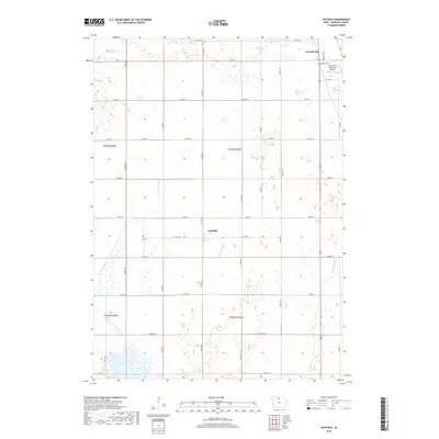
2018 Map of Hayfield
USGS Topo · Published 2018About this map
Forest City occupies the northeastern corner of this Hancock County landscape, where the Forest City Municipal Airport and Madison Cem sit along the city's periphery. The surrounding area is defined by its agricultural and hydrological patterns, featuring the parallel paths of the W Br Iowa River and the E Br Iowa River. A network of rural roads, including Co Rd R44 and Co Rd B16, connects the small settlement of Hayfield to the larger regional hub. In the southwest, the terrain transitions into the wetlands and open water of Eagle Lake, which is supported by managed waterways like Drainage Ditch Number 129. This survey provides a clear view of the modern rural infrastructure and natural drainage systems that characterize the northern Iowa plains.
Find a feature on this map
37 named features on this map. Tap any name to fly to it.
Don’t see what you’re looking for? This feature index may not catch every label — zoom into the map to look around manually.
Map Details
Editions of this 2018 Hayfield Map
This is the sole edition of this map. No revisions or reprints were ever made.
Other maps of this area

1954 · Mason City
USGS Topo · 1:250,000

1957 · Mason City
USGS Topo · 1:250,000

1958 · Mason City
USGS Topo · 1:250,000

1972 · Forest City
USGS Topo · 1:24,000

1972 · Hayfield
USGS Topo · 1:24,000

1972 · Crystal Lake
USGS Topo · 1:24,000

1972 · Pilot Knob
USGS Topo · 1:24,000
1972 · Thompson
USGS Topo · 1:24,000
1972 · Duncan
USGS Topo · 1:24,000
1972 · Miller
USGS Topo · 1:24,000