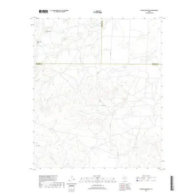
2019 Map of Hayrick Mountain
USGS Topo · Published 2019About this map
The intersection of Howard, Mitchell, and Sterling Counties forms the backdrop for this rugged West Texas landscape. The terrain is defined by prominent elevations such as Hayrick Mtn and Rattlesnake Mtn, which overlook a network of seasonal watercourses including Mustang Cr, Bull Cr, and Forest Cr. The presence of numerous man-made water features, such as Dipping Vat Tank, Jackson Tank, and Telephone Tank, underscores the area's primary focus on cattle ranching and livestock management. These reservoirs are vital infrastructure in a region where natural springs like Spring Tank are scarce. Toward the south, Gardener Draw and Rockwater Hole represent significant topographic shifts where drainage patterns converge, providing essential water sources for the remote ranch lands that dominate this tri-county border region. This survey illustrates the continued reliance on scattered water improvements and private road networks like Mcdonald RD to maintain the rural economy of the Texas plains.
Find a feature on this map
21 named features on this map. Tap any name to fly to it.
Don’t see what you’re looking for? This feature index may not catch every label — zoom into the map to look around manually.
Map Details
Editions of this 2019 Hayrick Mountain Map
This is the sole edition of this map. No revisions or reprints were ever made.
Other maps of this area

1941 · Big Spring South
USGS Topo · 1:62,500

1942 · Big Spring South
USGS Topo · 1:62,500

1954 · Big Spring
USGS Topo · 1:250,000

1954 · San Angelo
USGS Topo · 1:250,000

1958 · San Angelo
USGS Topo · 1:250,000

1958 · Big Spring
USGS Topo · 1:250,000

1962 · Hyman NE
USGS Topo · 1:24,000

1963 · Cumbie Draw NE
USGS Topo · 1:24,000

1963 · Buffalo Draw
USGS Topo · 1:24,000

1963 · Hayrick Mountain
USGS Topo · 1:24,000