
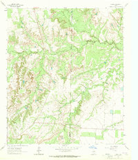
1963 Map of Hayrick Mountain
USGS Topo · Published 1964About this map
Hayrick Mountain and Rattlesnake Mountain anchor this high-plains landscape along the border of Howard, Sterling, and Mitchell Counties. Photogrammetric surveys from the early 1960s reveal a terrain defined by the search for water and energy, featuring an extensive network of named stock tanks like Dipping Vat Tank and Spring Tank alongside a developing Gas Field. The topography is dissected by seasonal drainages including Mustang Creek and Forest Creek, where the natural Rockwater Hole provided a reliable landmark in an otherwise arid region. Numerous family-named or property-specific windmills, such as Phillip Windmill and Coleman Windmill, indicate the intensive land management required for ranching in West Texas. A major Pipeline cuts through the southern reaches of the map, signaling the mid-century industrial shift overlaying traditional rangeland operations.
Find a feature on this map
26 named features on this map. Tap any name to fly to it.
Don’t see what you’re looking for? This feature index may not catch every label — zoom into the map to look around manually.
Map Details
Editions of this 1963 Hayrick Mountain Map
This is the sole edition of this map. No revisions or reprints were ever made.
Other maps of this area

1941 · Big Spring South
USGS Topo · 1:62,500

1942 · Big Spring South
USGS Topo · 1:62,500

1954 · Big Spring
USGS Topo · 1:250,000

1954 · San Angelo
USGS Topo · 1:250,000

1958 · San Angelo
USGS Topo · 1:250,000

1958 · Big Spring
USGS Topo · 1:250,000

1962 · Hyman NE
USGS Topo · 1:24,000

1963 · Cumbie Draw NE
USGS Topo · 1:24,000

1963 · Buffalo Draw
USGS Topo · 1:24,000
1963 · Hyman
USGS Topo · 1:24,000