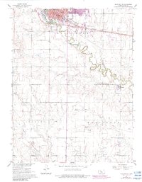
1961 Map of Hays South
USGS Topo · Published 1983About this map
Hays serves as the focal point of this Ellis County survey, showing the city's southward expansion toward the meandering Big Creek. The landscape transition from the institutional grounds of Fort Hays State College and the Old Fort Hays Museum to the agricultural expanses of Wheatland is clearly documented. Local history is deeply embedded in the layout of the town, featuring schools like St Joseph Sch and Washington Sch, alongside the prominent Courthouse.
Find a feature on this map
33 named features on this map. Tap any name to fly to it.
Don’t see what you’re looking for? This feature index may not catch every label — zoom into the map to look around manually.
Map Details
Editions of this 1961 Hays South Map
3 editions found
Other maps of this area

1896 · Hays
USGS Topo · 1:125,000

1955 · Great Bend
USGS Topo · 1:250,000

1957 · Great Bend
USGS Topo · 1:250,000

1958 · Great Bend
USGS Topo · 1:250,000

1961 · Yocemento
USGS Topo · 1:24,000

1961 · Hays South
USGS Topo · 1:24,000

1961 · Catharine
USGS Topo · 1:24,000
1961 · Hays North
USGS Topo · 1:24,000

1961 · Antonino
USGS Topo · 1:24,000

1961 · Victoria
USGS Topo · 1:24,000