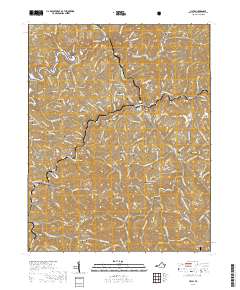
2019 Map of Haysi
USGS Topo · Published 2019About this map
Russell Fork and the McClure River carve through this corner of Dickenson County, shaping a landscape defined by sharp ridges and narrow hollows. The presence of numerous engineered rail passages, including Hills Mill Tunnel, Red Ridge Tunnel, and Pettit Tunnel, highlights the intensive infrastructure required to move resources through the Appalachians. Along the riverbanks, settlements like Haysi, Clinchco, and Steinman follow the topography, while the industrial footprint is visible in the route of the Flannagan Dam RR. Family genealogy is well-documented here through a high density of hillside burial sites, such as Sunderland Cem, Musick Cem, and Byers Cem. The northern boundary is marked by the Jefferson National Forest, where Pine Mountain stands as a prominent natural border, overlooking the winding waters of the Pound River.
Find a feature on this map
185 named features on this map. Tap any name to fly to it.
Don’t see what you’re looking for? This feature index may not catch every label — zoom into the map to look around manually.
Map Details
Editions of this 2019 Haysi Map
This is the sole edition of this map. No revisions or reprints were ever made.
Other maps of this area

1886 · Grundy
USGS Topo · 1:125,000

1890 · Grundy
USGS Topo · 1:125,000

1892 · Grundy
USGS Topo · 1:125,000

1913 · Clintwood
USGS Topo · 1:62,500

1914 · Bucu
USGS Topo · 1:48,000

1914 · Hurley
USGS Topo · 1:48,000

1915 · Clintwood
USGS Topo · 1:62,500

1915 · Regina
USGS Topo · 1:48,000

1915 · Hurley
USGS Topo · 1:48,000

1916 · Bucu
USGS Topo · 1:62,500