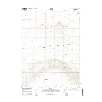
2015 Map of Haystack Flats
USGS Topo · Published 2015About this map
Haystack Flats characterizes this high-desert landscape in Sweetwater County, where a network of ephemeral watercourses and springs defines the movement of water through the terrain. The presence of Wild Rose Spring and its associated Wild Rose Draw indicates the importance of reliable water sources in this arid environment. Significant topographic landmarks like Man and Boy Buttes and the dramatic ridgelines of The Haystacks serve as dominant navigational anchors. The map reflects a modern management era with specific transportation routes such as Eureka Headquarters Rd and several Bureau of Land Management roads like BLM-4411 traversing the flats. Along the southern reaches, the natural curve of Horseshoe Bend and the drainage of East Haystack Wash further illustrate the complex hydrography of the region's draws and washes.
Find a feature on this map
18 named features on this map. Tap any name to fly to it.
Don’t see what you’re looking for? This feature index may not catch every label — zoom into the map to look around manually.
Map Details
Editions of this 2015 Haystack Flats Map
This is the sole edition of this map. No revisions or reprints were ever made.
Other maps of this area

1954 · Rock Springs
USGS Topo · 1:250,000

1958 · Rock Springs
USGS Topo · 1:250,000

1962 · Rock Springs
USGS Topo · 1:250,000

1970 · Red Desert SW
USGS Topo · 1:24,000
1970 · Red Desert SE
USGS Topo · 1:24,000

1970 · Manuel Gap
USGS Topo · 1:24,000
1970 · Barrel Springs SW
USGS Topo · 1:24,000

1970 · J O Dugway
USGS Topo · 1:24,000

1970 · Fort La Clede NE
USGS Topo · 1:24,000
1970 · Salazar Butte
USGS Topo · 1:24,000