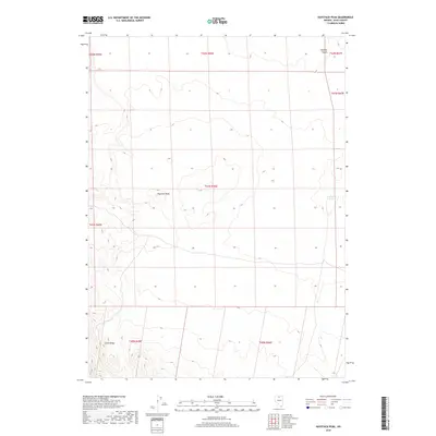
2018 Map of Haystack Peak
USGS Topo · Published 2018About this map
Haystack Peak serves as the central landmark for this high-elevation corner of the Owyhee Desert in Elko County. The landscape is defined by the sharp topographical relief of Castle Ridge and the vital water source at McFadden Spring. This 2018 survey documents a region where the vast, open spaces are organized by the Public Land Survey System, showing several township boundaries including t41n r46e and t40n r45e. The absence of developed roads or settlements highlights the isolation of this corner of Nevada, where the terrain is marked primarily by these named geographical features and spring locations critical for movement across the desert floor.
Find a feature on this map
12 named features on this map. Tap any name to fly to it.
Don’t see what you’re looking for? This feature index may not catch every label — zoom into the map to look around manually.
Map Details
Editions of this 2018 Haystack Peak Map
This is the sole edition of this map. No revisions or reprints were ever made.
Other maps of this area

1955 · McDermitt
USGS Topo · 1:250,000

1959 · McDermitt
USGS Topo · 1:250,000

1973 · Snowstorm Mtn
USGS Topo · 1:24,000
1973 · Rodear Flat
USGS Topo · 1:24,000

1973 · McCleary Wells
USGS Topo · 1:24,000

1973 · Haystack Peak
USGS Topo · 1:24,000

1973 · Humboldt Hill
USGS Topo · 1:24,000

1974 · Winters Ranch Reservoir
USGS Topo · 1:24,000

1974 · Burner Hills
USGS Topo · 1:24,000

1977 · Scraper Springs
USGS Topo · 1:24,000