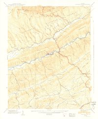
1939 Map of Hayters Gap
USGS Topo · Published 1939About this map
Clinch Mountain and Rich Mountain dominate this corner of the Virginia highlands, where a network of steep hollows and narrow valleys dictated early settlement patterns. Along the North Fork Holston River, agricultural and milling sites like Giesley Mill and White Mill provided local industry for rural communities such as Duncanville and Lindell. The landscape is dotted with several family-named landmarks and institutions, including the Jamison Cem and the Wesley Chapel Sch, which served as both a school and a social hub. In Poor Valley and Rich Valley, the distribution of numerous schools like Maiden Falls Sch and churches like Bethany Ch reflects a decentralized mountain society connected by logging roads and creek-side paths just before the modernization of the mid-20th century.
Find a feature on this map
91 named features on this map. Tap any name to fly to it.
Don’t see what you’re looking for? This feature index may not catch every label — zoom into the map to look around manually.
Map Details
Editions of this 1939 Hayters Gap Map
2 editions found
Other maps of this area

1891 · Abingdon
USGS Topo · 1:125,000

1894 · Abingdon
USGS Topo · 1:125,000

1897 · Bristol
USGS Topo · 1:125,000

1902 · Bristol
USGS Topo · 1:125,000

1909 · Abingdon
USGS Topo · 1:96,000

1911 · Abingdon
USGS Topo · 1:125,000

1918 · Carterton
USGS Topo · 1:62,500
1934 · Lebanon
USGS Topo · 1:24,000

1934 · Brumley
USGS Topo · 1:24,000

1934 · Wyndale
USGS Topo · 1:24,000