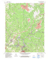
1992 Map of Hazard North
USGS Topo · Published 1992About this map
The industrial and community fabric of the Kentucky coalfields is clearly visible in this survey of the hills surrounding Hazard. The landscape is a dense network of resource extraction and local life, where extensive Strip Mine operations and numerous Mines flank established settlements like Blue Diamond, Hardburly, and Harveyton. This economic base is supported by the L & N RR and a distinctive Conveyor system that moves materials across the steep topography.
Find a feature on this map
71 named features on this map. Tap any name to fly to it.
Don’t see what you’re looking for? This feature index may not catch every label — zoom into the map to look around manually.
Map Details
Editions of this 1992 Hazard North Map
This is the sole edition of this map. No revisions or reprints were ever made.
Other maps of this area

1891 · Hazard
USGS Topo · 1:125,000

1913 · Buckhorn
USGS Topo · 1:62,500

1914 · Troublesome
USGS Topo · 1:62,500

1916 · Cornettsville
USGS Topo · 1:62,500

1916 · Hyden
USGS Topo · 1:48,000

1919 · Hyden
USGS Topo · 1:62,500

1954 · Noble
USGS Topo · 1:24,000

1954 · Krypton
USGS Topo · 1:24,000
1954 · Hyden East
USGS Topo · 1:24,000
1954 · Haddix
USGS Topo · 1:24,000