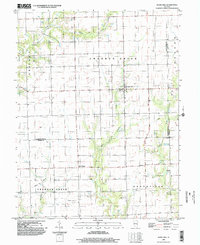
1998 Map of Hazel Dell
USGS Topo · Published 2002About this map
Hazel Dell and the rural intersection at Point Pleasant anchor this landscape along the border of Cumberland and Jasper Counties. The terrain is defined by a dense drainage network of the Crooked Creek system, including Chiuler Creek and the branching paths of the West Fork and East Fork. The settlement pattern reflects a deeply rooted agricultural and resource-based economy, where small community clusters like Advance are interspersed with industrial infrastructure. Modern land use is signaled by a series of subterranean Pipeline routes and an active Well Field to the south. This late-twentieth-century survey reveals the persistent structure of the public land survey system, with section lines and local roads following the geometric grid of the Grandville and Johnson townships.
Find a feature on this map
26 named features on this map. Tap any name to fly to it.
Don’t see what you’re looking for? This feature index may not catch every label — zoom into the map to look around manually.
Map Details
Editions of this 1998 Hazel Dell Map
This is the sole edition of this map. No revisions or reprints were ever made.
Other maps of this area

1933 · Toledo
USGS Topo · 1:62,500

1936 · Casey
USGS Topo · 1:48,000

1938 · Toledo
USGS Topo · 1:62,500

1940 · Greenup
USGS Topo · 1:62,500

1942 · Casey
USGS Topo · 1:62,500

1943 · Greenup
USGS Topo · 1:62,500

1943 · Casey
USGS Topo · 1:62,500

1953 · Indianapolis
USGS Topo · 1:250,000

1956 · Indianapolis
USGS Topo · 1:250,000

1956 · Annapolis
USGS Topo · 1:62,500