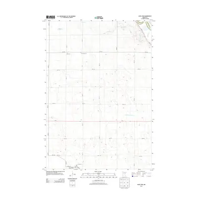
2013 Map of Hazel Run
USGS Topo · Published 2013About this map
The prairie landscape of Hazel Run is defined by a grid of agricultural section roads and the meandering drainage of Stony Run Cr. This 2013 survey illustrates a rural community anchored by its history, seen in the presence of Camp Release Cem and Bergen Cem located north of the primary settlement. The town of Hazel Run itself is concentrated at the intersection of Co Hwy-17 and Laurel Ave, where a Po and the traces of Railway St reflect the settlement's early logistical foundations. In the northwest, the Chippewa River Reservoir marks a significant hydrological feature near the border with Chippewa County. The transition from natural watercourses to managed agricultural drainage is evident in features like County Ditch Number Six a, which cuts across the central plains to support the surrounding farmland.
Find a feature on this map
26 named features on this map. Tap any name to fly to it.
Don’t see what you’re looking for? This feature index may not catch every label — zoom into the map to look around manually.
Map Details
Editions of this 2013 Hazel Run Map
This is the sole edition of this map. No revisions or reprints were ever made.
Other maps of this area

1953 · New Ulm
USGS Topo · 1:250,000

1957 · New Ulm
USGS Topo · 1:250,000

1958 · New Ulm
USGS Topo · 1:250,000

1962 · Wood Lake NW
USGS Topo · 1:24,000

1962 · Wood Lake
USGS Topo · 1:24,000

1965 · Montevideo
USGS Topo · 1:24,000

1965 · Clarkfield
USGS Topo · 1:24,000
1965 · Clarkfield NE
USGS Topo · 1:24,000

1965 · Asbury
USGS Topo · 1:24,000

1965 · Hazel Run
USGS Topo · 1:24,000