
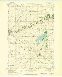
1962 Map of Wood Lake
USGS Topo · Published 1964About this map
The Yellow Medicine River carves a winding path through this corner of Southwest Minnesota, where the agrarian landscape is defined by an extensive network of drainage projects such as County Ditch No 49 and Judicial Ditch No 10. The map documents the critical role of rail transport in the early 1960s, showing the intersection of the Great Northern and Chicago and North Western lines. This rail infrastructure supports the local grain economy, connecting the township of Hanley Falls and the village of Wood Lake. Settlement patterns are further revealed through several community focal points, including the Lutheran Cem and Methodist Cem. The transition of the natural landscape is evident at the Sand Lake Bed and Mud Lake, illustrating the ongoing management of water resources for agricultural production in Yellow Medicine Co.
Find a feature on this map
31 named features on this map. Tap any name to fly to it.
Don’t see what you’re looking for? This feature index may not catch every label — zoom into the map to look around manually.
Map Details
Editions of this 1962 Wood Lake Map
2 editions found
Other maps of this area

1953 · New Ulm
USGS Topo · 1:250,000

1957 · New Ulm
USGS Topo · 1:250,000

1958 · New Ulm
USGS Topo · 1:250,000

1962 · Wood Lake NW
USGS Topo · 1:24,000

1962 · Cottonwood
USGS Topo · 1:24,000

1962 · School Grove Lake
USGS Topo · 1:24,000

1965 · Echo
USGS Topo · 1:24,000

1965 · Lone Tree Lake
USGS Topo · 1:24,000

1965 · Hazel Run
USGS Topo · 1:24,000
1965 · Granite Falls
USGS Topo · 1:24,000