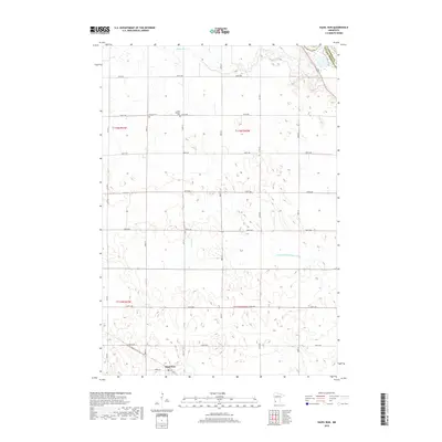
2019 Map of Hazel Run
USGS Topo · Published 2019About this map
Hazel Run sits at the southwestern edge of this landscape, serving as a focal point for the surrounding agricultural community in Yellow Medicine County. The terrain is defined by a grid of rural routes including 320th Ave and 500th St, which connect dispersed homesteads and farms. Local heritage is preserved at sites like Bergen Cemetery and Camp Release Cemetery, reflecting the early settlement history of the region. Water management is central to this prairie environment, evidenced by the winding path of Stony Run Creek in the north and the engineered channel of County Ditch Number Six a. The map also captures the jurisdictional boundary with Chippewa County in the northeast corner, where the topography shifts toward the river valley.
Find a feature on this map
26 named features on this map. Tap any name to fly to it.
Don’t see what you’re looking for? This feature index may not catch every label — zoom into the map to look around manually.
Map Details
Editions of this 2019 Hazel Run Map
This is the sole edition of this map. No revisions or reprints were ever made.
Other maps of this area

1953 · New Ulm
USGS Topo · 1:250,000

1957 · New Ulm
USGS Topo · 1:250,000

1958 · New Ulm
USGS Topo · 1:250,000

1962 · Wood Lake NW
USGS Topo · 1:24,000

1962 · Wood Lake
USGS Topo · 1:24,000

1965 · Montevideo
USGS Topo · 1:24,000

1965 · Clarkfield
USGS Topo · 1:24,000
1965 · Clarkfield NE
USGS Topo · 1:24,000

1965 · Asbury
USGS Topo · 1:24,000

1965 · Hazel Run
USGS Topo · 1:24,000