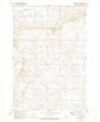
1971 Map of Hazelton NW
USGS Topo · Published 1973About this map
The Fort Rice Military Reservation Boundary marks the northwestern corner of this landscape, where the Missouri River valley's historical military influence meets the expansive upland plains. This 1971 survey captures a sparsely populated section of Emmons County characterized by the meandering courses of Horsehead Creek and Badger Creek, which carve through the Prairie View terrain. The settlement pattern is defined by isolated rural homesteads and agricultural legacy, evidenced by family-linked sites such as Gimble Cem and Meckle Cem. To the south, the map details the northern margins of the Long Lake National Wildlife Refuge, including the wetland environment of Sunburst Lake. The drainage network, featuring several unnamed springs and the prominent Spring, illustrates the vital water sources required for sustaining cattle and crops in this high prairie environment.
Find a feature on this map
10 named features on this map. Tap any name to fly to it.
Don’t see what you’re looking for? This feature index may not catch every label — zoom into the map to look around manually.
Map Details
Editions of this 1971 Hazelton NW Map
This is the sole edition of this map. No revisions or reprints were ever made.
Other maps of this area

1907 · Bismarck
USGS Topo · 1:125,000

1954 · Bismarck
USGS Topo · 1:250,000

1958 · Bismarck
USGS Topo · 1:250,000

1968 · Cannon Ball
USGS Topo · 1:24,000

1968 · Cannon Ball SE
USGS Topo · 1:24,000

1971 · Moffit SW
USGS Topo · 1:24,000

1971 · Hazelton
USGS Topo · 1:24,000

1971 · Moffit SE
USGS Topo · 1:24,000

1971 · Fort Rice
USGS Topo · 1:24,000

1971 · Hazelton SW
USGS Topo · 1:24,000