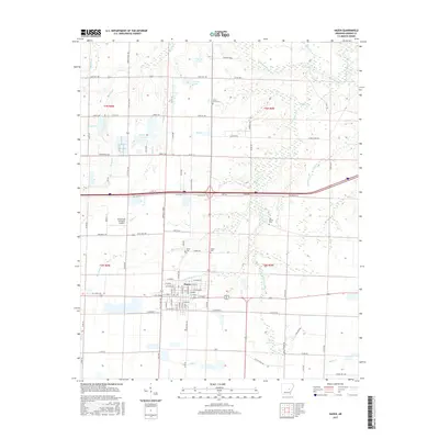
2017 Map of Hazen
USGS Topo · Published 2017About this map
The prairie landscape of Hazen is defined by a dense network of creek branches and agricultural drainage features in the Arkansas Grand Prairie region. The settlement is anchored by local landmarks such as Hazen Cem and the nearby Greenwalt Company Airport, while the surrounding township lines of T3N R6W and T2N R5W reveal a territory managed for water through numerous reservoirs. Waterways like Wattensas Bayou in the northeast and Hurricane Cr cutting through the center illustrate the low-lying nature of this terrain. Family and local history can be traced through sites such as Green Grove Cem and Old Bethel Cem, which sit amidst a grid of rural roads like Piety Rd and Stallings Rd. The presence of several distinct water bodies, including Crowley Lake and Jerome Lake, suggests a landscape heavily adapted for regional irrigation and land management.
Find a feature on this map
113 named features on this map. Tap any name to fly to it.
Don’t see what you’re looking for? This feature index may not catch every label — zoom into the map to look around manually.
Map Details
Editions of this 2017 Hazen Map
This is the sole edition of this map. No revisions or reprints were ever made.
Other maps of this area

1935 · Hazen
USGS Topo · 1:62,500

1935 · Clarendon
USGS Topo · 1:62,500

1937 · Stuttgart
USGS Topo · 1:62,500

1939 · Stuttgart
USGS Topo · 1:62,500

1941 · Hazen
USGS Topo · 1:62,500

1941 · De Valls Bluff
USGS Topo · 1:62,500

1941 · Clarendon
USGS Topo · 1:62,500

1948 · Helena
USGS Topo · 1:250,000

1950 · Helena
USGS Topo · 1:250,000

1955 · Helena
USGS Topo · 1:250,000