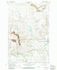
1968 Map of Hazen West
USGS Topo · Published 1986About this map
The Knife River valley defines this central North Dakota landscape, where the Northern Pacific railroad follows the river's path through the southern half of the quadrangle. In the late 1960s, the region’s economy was visibly tied to both heavy industry and agriculture, evidenced by the large Strip Mine operations and numerous Gravel Pits concentrated near the settlement of Truax. To the east, the edge of Hazen serves as the local hub, connected to the surrounding rural sections by a network of well-established section roads.
Find a feature on this map
15 named features on this map. Tap any name to fly to it.
Don’t see what you’re looking for? This feature index may not catch every label — zoom into the map to look around manually.
Map Details
Editions of this 1968 Hazen West Map
2 editions found
Other maps of this area

1954 · McClusky
USGS Topo · 1:250,000

1958 · McClusky
USGS Topo · 1:250,000

1968 · Red Butte
USGS Topo · 1:24,000

1968 · Beulah
USGS Topo · 1:24,000

1968 · Medicine Butte NE
USGS Topo · 1:24,000

1968 · Red Butte NW
USGS Topo · 1:24,000

1968 · Hazen West
USGS Topo · 1:24,000

1968 · Hazen East
USGS Topo · 1:24,000

1969 · Hazen NE
USGS Topo · 1:24,000

1969 · Beulah NE
USGS Topo · 1:24,000