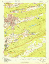
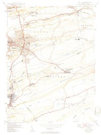
1950 Map of Hazleton
USGS Topo · Published 1950About this map
Coal-country industry and infrastructure dominate the landscape of the anthracite region just after the mid-century. Hazleton and West Hazleton serve as the primary urban hubs, densely gridded and supported by a massive network of the Lehigh Valley and Central RR of PA. The map reveal a landscape deeply shaped by extraction, with the red-tinted areas around Lattimer Mines (PO) and Stockton indicating the extent of built-up mining works and residential enclaves. Beyond the city center, specialized sites like the Hazleton State Hospital and St Josephs Hospital provide essential services to the growing population, while Ashmore Yards serves as a critical junction for rail operations. Smaller settlements such as Beaver Meadows and Jeansville cluster along the creeks and rail lines, illustrating the tight-knit relationship between the labor force and the transportation corridors of the Lehigh Valley.
Find a feature on this map
61 named features on this map. Tap any name to fly to it.
Don’t see what you’re looking for? This feature index may not catch every label — zoom into the map to look around manually.
Map Details
Editions of this 1950 Hazleton Map
2 editions found
Other maps of this area

1889 · Hazleton
USGS Topo · 1:62,500

1891 · Wilkesbarre
USGS Topo · 1:62,500

1891 · Hazleton
USGS Topo · 1:62,500

1892 · Mahanoy
USGS Topo · 1:62,500

1893 · Hazleton
USGS Topo · 1:62,500

1893 · Mahanoy
USGS Topo · 1:62,500

1894 · Shickshinny
USGS Topo · 1:62,500

1894 · Wilkesbarre
USGS Topo · 1:62,500

1943 · Scranton
USGS Topo · 1:125,000

1944 · Newark
USGS Topo · 1:250,000