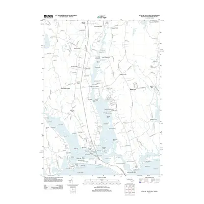
2012 Map of Head of Westport
USGS Topo · Published 2012About this map
The E Br Westport River and its western branch divide the landscape of Dartmouth and Westport, creating a complex geography of inlets, islands, and narrow passages. At the inland limit of navigation, the village of Head of Westport serves as a historic focal point, while farther south, the river widens around Great Island and Big Pine Island before reaching the Atlantic Ocean. The coastal character is defined by maritime landmarks like the Westport Harbor Entrance Light and the recreational spaces of East Horseneck Beach. Settlement patterns are distinctly concentrated at crossroads corners such as Gidleys Corner, Sissons Corner, and Slades Corner. Local history is visible in the preservation of the Central Village Commons and the proximity of family landmarks like the Almy Cem. Transportation and utility infrastructure include the Westport Airport and the specialized Horseneck Seaplane Base, reflecting the area's continued connection to both water and air travel in the modern era.
Find a feature on this map
189 named features on this map. Tap any name to fly to it.
Don’t see what you’re looking for? This feature index may not catch every label — zoom into the map to look around manually.
Map Details
Editions of this 2012 Head of Westport Map
This is the sole edition of this map. No revisions or reprints were ever made.
Other maps of this area

1885 · New Bedford
USGS Topo · 1:62,500

1885 · Sakonnet
USGS Topo · 1:62,500

1888 · New Bedford
USGS Topo · 1:62,500

1888 · Fall River
USGS Topo · 1:62,500

1888 · Sakonnet
USGS Topo · 1:62,500

1893 · Sakonnet
USGS Topo · 1:62,500

1893 · Fall River
USGS Topo · 1:62,500

1893 · New Bedford
USGS Topo · 1:62,500

1918 · New Bedford
USGS Topo · 1:62,500

1919 · Fall River
USGS Topo · 1:62,500