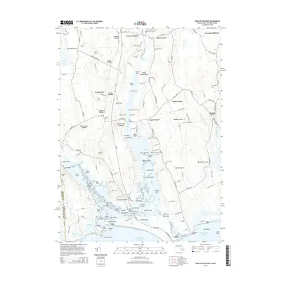
2015 Map of Head of Westport
USGS Topo · Published 2015About this map
Head of Westport and the branching estuaries of the Westport River anchor this 2015 study of the coastal Massachusetts and Rhode Island border. The landscape is defined by its maritime geography, where the East Branch Westport River flows past numerous points and islands like Big Pine Island and Gunning Island toward the Atlantic Ocean. Inland, the map reveals a high density of named crossroads and hamlets, including Central Village, South Westport, and Russells Mills, reflecting centuries of agricultural and village development. Local history is deeply etched into the land through sites like Beech Grove Cem and Linden Grove Cem. The transition from the tidal flats of Sanford Flat to the aviation fields of Westport Airport demonstrates the area's continued evolution as a residential and recreation hub on the Buzzards Bay periphery.
Find a feature on this map
168 named features on this map. Tap any name to fly to it.
Don’t see what you’re looking for? This feature index may not catch every label — zoom into the map to look around manually.
Map Details
Editions of this 2015 Head of Westport Map
This is the sole edition of this map. No revisions or reprints were ever made.
Other maps of this area

1885 · New Bedford
USGS Topo · 1:62,500

1885 · Sakonnet
USGS Topo · 1:62,500

1888 · New Bedford
USGS Topo · 1:62,500

1888 · Fall River
USGS Topo · 1:62,500

1888 · Sakonnet
USGS Topo · 1:62,500

1893 · Sakonnet
USGS Topo · 1:62,500

1893 · Fall River
USGS Topo · 1:62,500

1893 · New Bedford
USGS Topo · 1:62,500

1918 · New Bedford
USGS Topo · 1:62,500

1919 · Fall River
USGS Topo · 1:62,500