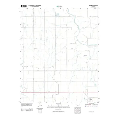
2010 Map of Headrick
USGS Topo · Published 2010About this map
Headrick and the surrounding agricultural landscape of Jackson County are defined by a precise grid of rural section roads and the meandering path of the North Fork Red River. In this western Oklahoma terrain, the Navajo Mountains provide a distinct topographic break from the surrounding fields, while the Navajo Cemetery stands as a point of genealogical interest near the small community of Friendship. The map detail follows the transition from the older transportation routes like Old Hwy 62 to the modern rural road system, including N2090 Rd and E1570 Rd. Water management is evident through features such as the Oknoname 065002 Dam and the drainage of Stinking Creek, illustrating how the land has been engineered to support the local farming economy.
Find a feature on this map
25 named features on this map. Tap any name to fly to it.
Don’t see what you’re looking for? This feature index may not catch every label — zoom into the map to look around manually.
Map Details
Editions of this 2010 Headrick Map
This is the sole edition of this map. No revisions or reprints were ever made.
Other maps of this area

1955 · Lawton
USGS Topo · 1:250,000

1963 · Altus SE
USGS Topo · 1:24,000

1964 · Tipton SE
USGS Topo · 1:24,000

1964 · Altus
USGS Topo · 1:24,000

1964 · Tipton
USGS Topo · 1:24,000

1964 · Warren
USGS Topo · 1:24,000

1964 · Headrick
USGS Topo · 1:24,000
1964 · Roosevelt
USGS Topo · 1:24,000

1964 · Long Mountain
USGS Topo · 1:24,000

1971 · Blair
USGS Topo · 1:24,000