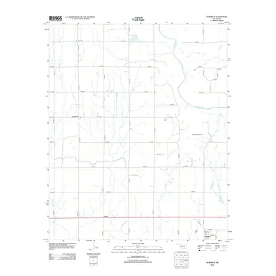
2012 Map of Headrick
USGS Topo · Published 2012About this map
Headrick anchors this southwestern Oklahoma landscape along the southern edge of the quadrangle, where residential streets like Main St and Payne St meet the corridor of Old Hwy 62. This 2012 survey illustrates the agricultural character of Jackson County, where a rigid grid of section roads like E 1600 Rd and N 2120 Rd dissects the plains. The N Fork Red River meanders across the northern half of the map, providing a natural contrast to the geometric precision of the surrounding farmland.
Find a feature on this map
35 named features on this map. Tap any name to fly to it.
Don’t see what you’re looking for? This feature index may not catch every label — zoom into the map to look around manually.
Map Details
Editions of this 2012 Headrick Map
This is the sole edition of this map. No revisions or reprints were ever made.
Other maps of this area

1955 · Lawton
USGS Topo · 1:250,000

1963 · Altus SE
USGS Topo · 1:24,000

1964 · Tipton SE
USGS Topo · 1:24,000

1964 · Altus
USGS Topo · 1:24,000

1964 · Tipton
USGS Topo · 1:24,000

1964 · Warren
USGS Topo · 1:24,000

1964 · Headrick
USGS Topo · 1:24,000
1964 · Roosevelt
USGS Topo · 1:24,000

1964 · Long Mountain
USGS Topo · 1:24,000

1971 · Blair
USGS Topo · 1:24,000