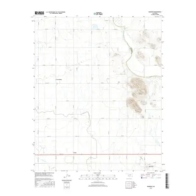
2016 Map of Headrick
USGS Topo · Published 2016About this map
The Navajo Mountains rise as a prominent landform on this southwest Oklahoma landscape, standing just east of the North Fork Red River. This river corridor defines the boundary between Kiowa Co and Jackson Co, where the terrain transitions from river bottoms to upland plains. The settlement of Headrick serves as a focal point in the southeast, situated along Old Hwy 62 and Main St. Further west and north, the rural communities of Ozark and Friendship represent the agricultural grid that dominates the region. Local history is anchored by the Navajo Cem, located near the base of the mountains, while the winding course of Stinking Cr drains the southern portion of the sheet. The map reveals a highly structured section-line road system, including Co Rd E 164 and Navajoe Rd, which supports the area's farming legacy.
Find a feature on this map
42 named features on this map. Tap any name to fly to it.
Don’t see what you’re looking for? This feature index may not catch every label — zoom into the map to look around manually.
Map Details
Editions of this 2016 Headrick Map
This is the sole edition of this map. No revisions or reprints were ever made.
Other maps of this area

1955 · Lawton
USGS Topo · 1:250,000

1963 · Altus SE
USGS Topo · 1:24,000

1964 · Tipton SE
USGS Topo · 1:24,000

1964 · Altus
USGS Topo · 1:24,000

1964 · Tipton
USGS Topo · 1:24,000

1964 · Warren
USGS Topo · 1:24,000

1964 · Headrick
USGS Topo · 1:24,000
1964 · Roosevelt
USGS Topo · 1:24,000

1964 · Long Mountain
USGS Topo · 1:24,000

1971 · Blair
USGS Topo · 1:24,000