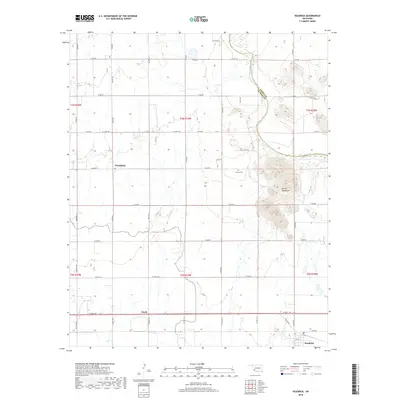
2018 Map of Headrick
USGS Topo · Published 2018About this map
Navajo Mountains rise distinctly in the eastern portion of this Jackson County landscape, providing a topographical anchor near the Kiowa County line. The North Fork Red River snakes southward through the territory, defining the boundary between counties before it meanders toward the southern reaches of the quadrangle. The agricultural and rural character of the area is evidenced by the grid of county roads, such as N2090 Rd and E1570 Rd, which connect small dispersed settlements. Near the base of the prominent highlands lies the Navajo Cem, a site of local genealogical significance. Further south, the town of Headrick serves as a primary point of interest along the main thoroughfare, while smaller locales like Ozark and Friendship represent the enduring small-town footprints across these Oklahoma plains.
Find a feature on this map
48 named features on this map. Tap any name to fly to it.
Don’t see what you’re looking for? This feature index may not catch every label — zoom into the map to look around manually.
Map Details
Editions of this 2018 Headrick Map
This is the sole edition of this map. No revisions or reprints were ever made.
Other maps of this area

1955 · Lawton
USGS Topo · 1:250,000

1963 · Altus SE
USGS Topo · 1:24,000

1964 · Tipton SE
USGS Topo · 1:24,000

1964 · Altus
USGS Topo · 1:24,000

1964 · Tipton
USGS Topo · 1:24,000

1964 · Warren
USGS Topo · 1:24,000

1964 · Headrick
USGS Topo · 1:24,000
1964 · Roosevelt
USGS Topo · 1:24,000

1964 · Long Mountain
USGS Topo · 1:24,000

1971 · Blair
USGS Topo · 1:24,000