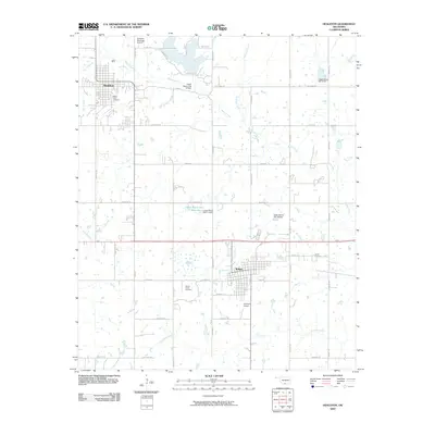
2009 Map of Healdton
USGS Topo · Published 2009About this map
Healdton and Wilson anchor this Carter County landscape, which is defined by a complex network of rural roads and water management structures. The area is marked by numerous flood control dams and reservoirs, including Upper Bayou Site 17 Reservoir and the Upper Bayou Site 10 Dam, which regulate the flow of Walnut Creek and its tributaries. For those researching local family history, the map includes significant burial sites such as Mount Olive Cemetery near the Healdton city limits, Hewitt Cemetery to the east, and Bomar Point Cemetery located just south of Bomar Point. The presence of Exxon Rd and Santa Fe Rd suggests the historical importance of the petroleum and rail sectors in shaping the township's development and transport patterns during the early 21st century.
Find a feature on this map
51 named features on this map. Tap any name to fly to it.
Don’t see what you’re looking for? This feature index may not catch every label — zoom into the map to look around manually.
Map Details
Editions of this 2009 Healdton Map
This is the sole edition of this map. No revisions or reprints were ever made.
Other maps of this area

1901 · Addington
USGS Topo · 1:125,000

1901 · Ardmore
USGS Topo · 1:125,000

1918 · Ardmore
USGS Topo · 1:125,000

1957 · Ardmore
USGS Topo · 1:250,000

1963 · Ardmore
USGS Topo · 1:250,000

1969 · Healdton
USGS Topo · 1:24,000

1969 · Lone Grove
USGS Topo · 1:24,000
1969 · Healdton SW
USGS Topo · 1:24,000
1969 · Milo
USGS Topo · 1:24,000
1969 · Healdton SE
USGS Topo · 1:24,000