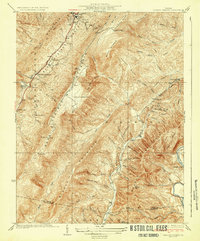
1933 Map of Healing Springs
USGS Topo · Published 1933About this map
Hot Springs and the surrounding resort district of Bath County are depicted in detail during the early 1930s, showing a landscape defined by steep ridges and narrow valleys. This survey, conducted by Hersey Munroe and others, captures the local infrastructure of the era, from the established resort at Healing Springs to the aviation facility at Ingalls Landing Field. The map records numerous small settlements and farmsteads like Tinkertown and Holly Hurst Farm, tucked between the prominent peaks of Warm Springs Mountain and Beards Mountain. Education and recreation are noted through the Woods Sch and Camp Kamata near the Cowpasture River. The western portion of the sheet follows the corridor of State Highway No 800, connecting rural communities like Ashwood and Midway against the backdrop of the Allegheny Mountains.
Find a feature on this map
58 named features on this map. Tap any name to fly to it.
Don’t see what you’re looking for? This feature index may not catch every label — zoom into the map to look around manually.
Map Details
Editions of this 1933 Healing Springs Map
3 editions found

Other maps of this area

1894 · Natural Bridge
USGS Topo · 1:125,000

1901 · Monterey
USGS Topo · 1:125,000

1923 · Warm Springs
USGS Topo · 1:48,000

1926 · Warm Springs
USGS Topo · 1:62,500

1929 · Falling Spring
USGS Topo · 1:24,000

1930 · Warm Springs Run
USGS Topo · 1:24,000

1930 · Mountain Grove
USGS Topo · 1:24,000

1931 · Healing Springs
USGS Topo · 1:24,000

1932 · Falling Spring
USGS Topo · 1:31,680

1933 · Mountain Grove
USGS Topo · 1:31,680