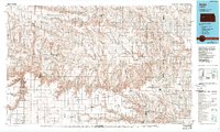
1985 Map of Healy
USGS Topo · Published 1989About this map
The Smoky Hill River carves a path through the high plains of western Kansas, where dramatic geological formations like the Monument Rocks National Natural Landmark and Castle Rock rise from the prairie. This landscape is defined by its deep historical layers, shown here as it appeared in the mid-1980s. The map traces the approximate routes of the historic Butterfield Trail and Overland Trail, alongside the modern industrial infrastructure of the Missouri Pacific railroad.
Find a feature on this map
66 named features on this map. Tap any name to fly to it.
Don’t see what you’re looking for? This feature index may not catch every label — zoom into the map to look around manually.
Map Details
Editions of this 1985 Healy Map
2 editions found
Other maps of this area

1892 · Ness
USGS Topo · 1:125,000

1893 · Ellis
USGS Topo · 1:125,000

1893 · Hill
USGS Topo · 1:125,000

1894 · Ness
USGS Topo · 1:125,000

1939 · Lake Mc Bride
USGS Topo · 1:24,000

1939 · Sandon
USGS Topo · 1:62,500

1939 · Pence
USGS Topo · 1:62,500

1940 · Scott City
USGS Topo · 1:62,500

1941 · Modoc
USGS Topo · 1:62,500

1941 · Pence
USGS Topo · 1:62,500