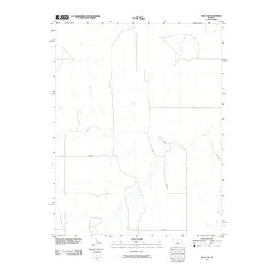
2009 Map of Healy NW
USGS Topo · Published 2009About this map
The Smoky Hill River cuts through the northeast corner of this western Kansas landscape, providing a primary drainage point for the surrounding prairie. This area is characterized by a network of seasonal watercourses, including the descriptive Hell Creek and the bifurcated drainage of West Salt Creek and East Salt Creek. The map documents a sparse, rural infrastructure defined by a grid of local roads such as N Willow Rd and Co Rd 250, which reflect the section-line organization typical of the Great Plains. Named trackways like Bison Rd and Bison I suggest local landmarks or ranching routes that navigate the subtle topographical shifts of the High Plains. Along the northern boundary, the Gove A line marks the transition into the adjacent county, illustrating the administrative divisions that shaped the settlement of this region.
Find a feature on this map
14 named features on this map. Tap any name to fly to it.
Don’t see what you’re looking for? This feature index may not catch every label — zoom into the map to look around manually.
Map Details
Editions of this 2009 Healy NW Map
This is the sole edition of this map. No revisions or reprints were ever made.
Other maps of this area

1939 · Sandon
USGS Topo · 1:62,500

1942 · Sandon
USGS Topo · 1:62,500

1955 · Scott City
USGS Topo · 1:250,000

1958 · Scott City
USGS Topo · 1:250,000

1974 · Cheyenne Creek
USGS Topo · 1:24,000
1974 · Orion SE
USGS Topo · 1:24,000

1974 · Healy NW
USGS Topo · 1:24,000

1974 · Elkader
USGS Topo · 1:24,000

1974 · Manning
USGS Topo · 1:24,000

1974 · Healy
USGS Topo · 1:24,000