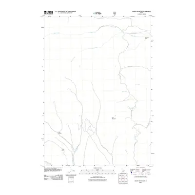
2011 Map of Heart Mountain
USGS Topo · Published 2011About this map
Black Mountain rises as the central landmark of this drainage basin, where several key waterways converge within the remote landscape of Clark County. The presence of Emigrant Trail Rd along the northern boundary provides a historical link to the transcontinental movement of the mid-19th century, cutting across the watershed of Webber Creek. To the south, the topography is defined by significant depressions and valleys, including Slate Basin and Heart Canyon. This high-country drainage network is intricate, with Myers Creek and Crooked Creek feeding into the larger system that includes Deep Creek and its tributary, South Fork Deep Creek. The map details a network of forest development roads and trails, such as NFD 191 Trl, which navigate the steep terrain between Robertson Gulch and the surrounding peaks.
Find a feature on this map
23 named features on this map. Tap any name to fly to it.
Don’t see what you’re looking for? This feature index may not catch every label — zoom into the map to look around manually.
Map Details
Editions of this 2011 Heart Mountain Map
This is the sole edition of this map. No revisions or reprints were ever made.
Other maps of this area

1955 · Dubois
USGS Topo · 1:250,000

1957 · Scott Peak
USGS Topo · 1:62,500

1957 · Edie Ranch
USGS Topo · 1:62,500

1958 · Dubois
USGS Topo · 1:250,000

1969 · Shamrock Gulch
USGS Topo · 1:24,000

1969 · Copper Mtn
USGS Topo · 1:24,000

1969 · Lidy Hot Springs
USGS Topo · 1:24,000

1983 · Dubois
USGS Topo · 1:100,000
1987 · Deadman Lake
USGS Topo · 1:24,000
1987 · Fritz Peak
USGS Topo · 1:24,000