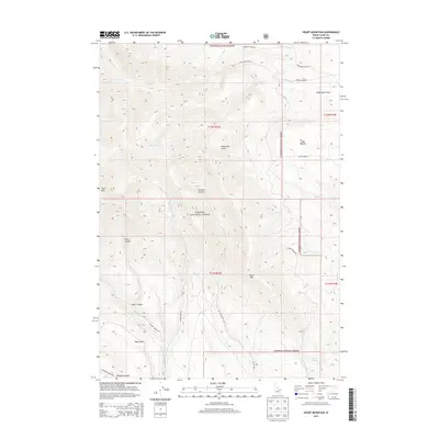
2013 Map of Heart Mountain
USGS Topo · Published 2013About this map
Targhee National Forest dominates this Clark County landscape, where the high-altitude terrain is defined by prominent peaks like Heart Mtn and Black Mtn. The survey documents a network of primitive access routes and historical paths, most notably Emigrant Trail Rd winding through the northern sections. This road follows a traditional corridor of movement through the mountains, connecting different drainages such as Webber Cr and McNeary Cr. In the southern reaches, the land drops into the Slate Basin near the mouth of Nicholia Canyon, illustrating the transition from timbered forest slopes to open mountain basins. The presence of Warm Springs and Warm Springs Cr in the southeast suggests the geothermal activity common to this region of Idaho. This 2013 edition details the modern forest road system, including Nat For Dev Rd 194 and Nat For Dev Rd 198, which serve as the primary conduits for today's mountain travel.
Find a feature on this map
31 named features on this map. Tap any name to fly to it.
Don’t see what you’re looking for? This feature index may not catch every label — zoom into the map to look around manually.
Map Details
Editions of this 2013 Heart Mountain Map
This is the sole edition of this map. No revisions or reprints were ever made.
Other maps of this area

1955 · Dubois
USGS Topo · 1:250,000

1957 · Scott Peak
USGS Topo · 1:62,500

1957 · Edie Ranch
USGS Topo · 1:62,500

1958 · Dubois
USGS Topo · 1:250,000

1969 · Shamrock Gulch
USGS Topo · 1:24,000

1969 · Copper Mtn
USGS Topo · 1:24,000

1969 · Lidy Hot Springs
USGS Topo · 1:24,000

1983 · Dubois
USGS Topo · 1:100,000
1987 · Deadman Lake
USGS Topo · 1:24,000
1987 · Fritz Peak
USGS Topo · 1:24,000