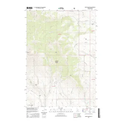
2017 Map of Heart Mountain
USGS Topo · Published 2017About this map
Emigrant Trail segments wind through this high-elevation corner of Idaho, following the complex drainage network of Targhee National Forest. The landscape is dominated by significant vertical relief, ranging from the volcanic prominence of Heart Mountain in the west to Black Mtn and Black Mountain in the central and southeastern reaches. The mapping reveals a rugged geography of deep canyons and high basins, including Grouse Canyon and Slate Basin, where seasonal water sources like Crooked Creek and Myers Creek have carved distinct paths toward the Medicine Lodge Bench. Historical movement through the area is evidenced by established routes such as Deep Creek Rd and various Forest Service developments. This high country is punctuated by specialized ecological features, such as Antelope Lakes and the thermal presence of Warm Springs, providing a detailed look at the hydrology of the Bitterroot Range foothills.
Find a feature on this map
39 named features on this map. Tap any name to fly to it.
Don’t see what you’re looking for? This feature index may not catch every label — zoom into the map to look around manually.
Map Details
Editions of this 2017 Heart Mountain Map
This is the sole edition of this map. No revisions or reprints were ever made.
Other maps of this area

1955 · Dubois
USGS Topo · 1:250,000

1957 · Scott Peak
USGS Topo · 1:62,500

1957 · Edie Ranch
USGS Topo · 1:62,500

1958 · Dubois
USGS Topo · 1:250,000

1969 · Shamrock Gulch
USGS Topo · 1:24,000

1969 · Copper Mtn
USGS Topo · 1:24,000

1969 · Lidy Hot Springs
USGS Topo · 1:24,000

1983 · Dubois
USGS Topo · 1:100,000
1987 · Deadman Lake
USGS Topo · 1:24,000
1987 · Fritz Peak
USGS Topo · 1:24,000