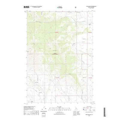
2020 Map of Heart Mountain
USGS Topo · Published 2020About this map
Targhee National Forest dominates this high-altitude landscape in Clark County, where the southern reaches of the Beaverhead Mountains meet the high desert basins. The terrain is defined by dramatic elevation changes between Heart Mountain and Black Mountain, which overlook a network of seasonal drainages and canyons. The historical imprint of western migration is evident along the Emigrant Trail, which traverses the eastern slopes near Medicine Lodge Bench. This corridor reflects the long-standing importance of this pass for travelers crossing between Idaho and Montana. Water sources are scarce but significant in this environment, represented by the Antelope Lakes and Warm Springs at the southern edge of the quadrangle. The map details a landscape transition from the timbered heights of Grouse Canyon to the broad, arid expanse of Slate Basin, providing a clear view of the drainage patterns of Webber Creek and McNeary Creek.
Find a feature on this map
40 named features on this map. Tap any name to fly to it.
Don’t see what you’re looking for? This feature index may not catch every label — zoom into the map to look around manually.
Map Details
Editions of this 2020 Heart Mountain Map
This is the sole edition of this map. No revisions or reprints were ever made.
Other maps of this area

1955 · Dubois
USGS Topo · 1:250,000

1957 · Scott Peak
USGS Topo · 1:62,500

1957 · Edie Ranch
USGS Topo · 1:62,500

1958 · Dubois
USGS Topo · 1:250,000

1969 · Shamrock Gulch
USGS Topo · 1:24,000

1969 · Copper Mtn
USGS Topo · 1:24,000

1969 · Lidy Hot Springs
USGS Topo · 1:24,000

1983 · Dubois
USGS Topo · 1:100,000
1987 · Deadman Lake
USGS Topo · 1:24,000
1987 · Fritz Peak
USGS Topo · 1:24,000